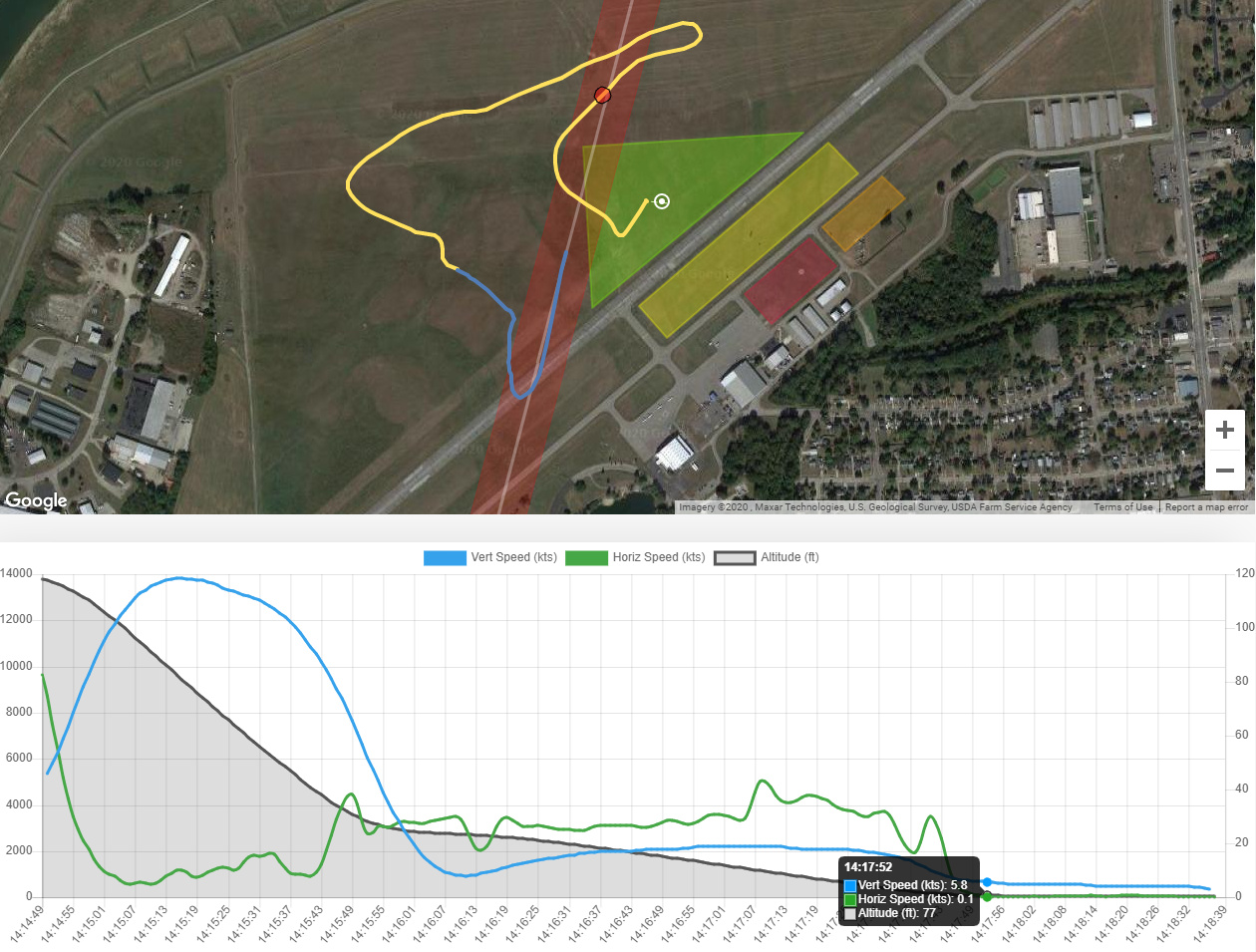
First, the time that my mouse is hovering over says I was going 0.1 kts horizontally and 5.8 kts vertically at 77 feet, which shows that the altitude number is way off even though the altimeter read 0 when I landed. In addition, notice where it places the marker in my pattern. It places it in my downwind leg where I was probably at about 700 or 800 feet or so. It seems that the marker is just not being placed properly on the map when mousing over the graph.
I also don’t think the vertical speed while under canopy is being logged or displayed properly. I always do a 90 degree front riser turn for my final approach at around 250 feet AGL. This means I should see a spike in vertical speed and a brief slight drop in horizontal speed followed by a spike in horizontal speed with my vertical speed dropping and flattening. I see the drop and spike in horizontal speed on the graph (although the altitude listed is not correct). However, I do not see this with the vertical speed on the graph.
All of my jump logs on the Dekunu Cloud are like this.
So, I just noticed that when I view the 3D viz for my jumps, the altitude accurately matches the point in the flight path. However, the DZ landing areas appear to be anchored at sea level. So when my flight path gets to around 640-655 feet (the elevation of the airport), the flight path goes under the satellite image of the DZ. It seems to be treating 0 AGL as 0 MSL, but the altitude reads properly in the flight path. The flight path just seems to be anchored to sea level, not ground level.
The altitude being shown in my original post is also offset some how and then gets worse as it gets lower because it doesn’t want the graph to go below 0 (which it shouldn’t, but it wants to because the altitude is being anchored atsea level, not ground level.)
Hi @jphart03 Thanks for posting, we are currently working on the algorithms for post-jump analysis and data output. We can look into this for you but need the action ID. The best way to bring this to the developers attention is to mark the action for review. Here are instructions if you do not know how to do that
Hey @jphart03 a couple of examples would be great but no need to mark all of them for sure. If you can provide what you think the accurate info should be that would be valuable
@Roofstomp We are re-working EVERYTHING, its a big job. Thats not to say we have nailed it, there could still be some inaccuracies, it is too soon to say. We’d love to hear some feedback from you guys once the re-processing is complete
@Tracy - cool, I’ll watch for when that finishes. I was looking at some of the jump files and toyed briefly with attempting to develop some of my own algorithms , but for now I think it makes a lot more sense to see how your efforts play out. Especially given my lack of experience in analyzing map coordinates.
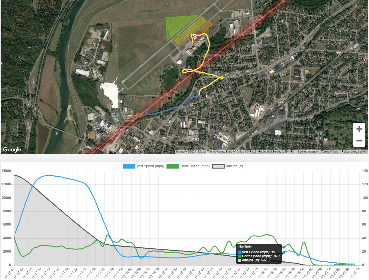
So this is still not showing up properly. I believe the graph is fairly accurate, but it is being stretched somewhere during freefall which is throwing off the rest of the graphs and misaligning the flight path. For example, on the jump below, at 18:19:41, I begin my 90 degree front riser turn for final, but notice where it places the marker on the flight path. I places it where I start my downwind leg at around 1,000 feet (yet the graph says that I was at 492.3 feet at that point, which is also incorrect). It is as if the altitude graph is not aligned properly with the speed graphs and none of the graphs are aligned properly with the flight path.
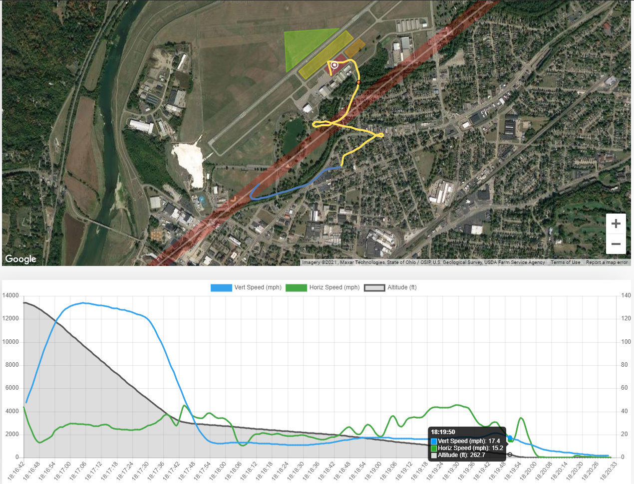
Notice where the altitude graph dips at 18:19:50. That is where I actually begin my turn for final. The altitude on the graph is correct (262.7 feet), but it is not aligned properly with the speed graphs or the flight path (where it places the marker in the middle of my downwind leg). It is worth noting that the altitudes are properly displayed on the 3D visualizer.
It’s disappointing. I bought the Dekunu One for the data. I don’t even bother checking the flight data afterwards because I know it won’t be right. I don’t even feel like I could even sell it in good faith knowing that this continues to be an issue.
Yes. I agree. It is disappointing. The data is what is supposed to set this device apart from every other altimeter out there. For the price paid, one expects all device functions to work properly. In this case, one of those functions is logging data for later review. When this data cannot be properly presented or retrieved, then this function should not be advertised since it is not worth paying for. At that point, it is in beta testing and I do not like paying money to be a beta tester. Some functions have even been promised since the initial release and are still not available. I feel that a slimmer, waterproof version with a stronger GPS, longer battery life, and a screen with less glare (the Dekunu Two) will be released before they release the software features that were originally promised for this device.
I’ve the same issues on mine. All jumps have inaccurate data. I logged a good example for review, saying I initiated a 270 on my JFX from 120 feet and only hit 45km/h!
Have had a look over every jump, none of them appear remotely accurate.
I just posted a similar thread, this morning. I am also experiencing this same inaccuracy. I know specific jumps that I turned my landing pattern legs at specific altitudes and then checked the cloud data and found it very inaccurate. ( have checked it against other devices, as well ) Has there been any kind of movement/improvement on this?
@wjr If you can mark one of the actions for review we can investigate, this can be the result of poor GPS connection or it may be something the devs can tweak, the maps are currently in beta as we continue to work on improvements so any feedback you have is appreciated
@Tracy thank you. This has happened when the GPS stats show good connection, so I will chalk this up to not being aware that the maps were still in development. I have marked for review the ones that I discovered this variance on so that you guys can see what I am speaking of, and left notes of actual altitudes at specific points in hopes that it helps. ( differences of 800 - 500 feet ) Thank you.
For me, the issue appears to occur on every jump. Does this occur on each of your jumps? It’s almost like there is an exponential offset that worsens as the altitude gets lower.
@jphart03 I only discovered it because I was paying very acute attention to specific altitudes and way points on those jumps, but I just went and looked and you are correct. ( !!! ) My patterns are very clearly obvious and altitudes reported on the graph and map are VERY inaccurate. One shows me starting my pattern at a very familiar way point that I use for 800’ - 1000’ ( depending on the wind that day ) and it’s reporting 150’. There is simply no way I could have flown my whole pattern if I started at 150’. Another jump shows 75’, and another shows 0’ for the very start of my pattern. It’s frustrating. I cannot find any rhyme or reason to it and I do a lot of math every day.
(EDIT)
You are correct though, in that it is almost like it starts getting exponentially worse once I am below 2,500’. I know for a fact that I have compared the displayed altitude with other altimeters all the way from altitude to my turn onto final and it is usually pretty close. So, I’d have to agree that it is something that is happening to the data after it gets uploaded. (/EDIT)
Thanks guys, I have forwarded this thread on to the developers as well as the actions for review @wjr submitted, once I hear back I will post in this thread

 , but for now I think it makes a lot more sense to see how your efforts play out. Especially given my lack of experience in analyzing map coordinates.